As Hurricane Francine closes in on landfall, multiple systems swirl in the Atlantic
Published in Weather News
MIAMI — Hurricane Francine is on track to strike Louisiana’s coast with 100mph winds and up to 10 feet of storm surge Wednesday afternoon, the third storm to make U.S. landfall this season.
The National Hurricane Center’s forecast again calls for Francine to hit as a Category 2 storm after the hurricane strengthened overnight in the warmer-than-average waters of the Gulf of Mexico. However, forecasters said a last-minute burst of dry air and wind shear could halt the storm’s development just before landfall.
“The hurricane is not expected to continue strengthening through landfall, but will continue to pose a significant risk of life-threatening storm surge and damaging winds to locations in the warning areas,” forecasters warned in the 5 a.m. discussion.
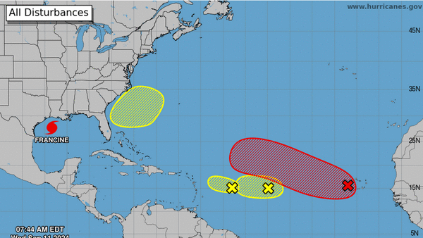
Overnight, the hurricane center also began tracking two new disturbances in the Atlantic, on top of the two it was already watching. None appear to be immediate threats to land.
The newest system, off the southeast coast, has only a 20% chance of formation in the next seven days. The hurricane center noted that “some subtropical or tropical development is possible during the early part of next week as the system meanders over the Gulf Stream or drifts slowly northward.”
The other three disturbances are in a conga line in the main development region.
The one farthest east — disturbance one — has the best chance of strengthening into a tropical depression. Forecasters gave it 90% chance of developing into a tropical depression within the week and a 50% chance of developing in the next two days.
Early computer models are not enthusiastic about this disturbance, and most show it petering out away from land. However, it’s too early to know for sure, and the models are much more accurate after a depression has formed.
The other two systems have low chances of development anytime soon. The middle one is down to 30%, a slow decline over the last few days, and the westernmost one sits at a 10% chance of formation.
“The proximity of dry air near the system is expected to limit additional development over the next couple of days before environmental conditions become even less conducive by this weekend,” forecasters wrote.
©2024 Miami Herald. Visit at miamiherald.com. Distributed by Tribune Content Agency, LLC.


Comments