New Jersey wildfires sending smoke, poor air quality to NYC
Published in News & Features
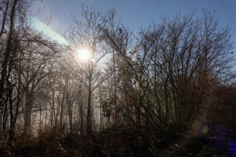
A series of wildfires ravaging parts of rain-starved New Jersey were sending plumes of smoke across the Hudson River and into New York, leaving much of the city blanketed in an eerie haze.
At least six fires, all of them fueled by bone-dry conditions and windy weather, were actively burning across the Garden State on Saturday, from the Pinelands in central and western parts of New Jersey to the New York City suburbs.
Efforts to battle back the fires had been made all the more difficult by the dry conditions. New Jersey has not received measurable rain in more than a month, setting a new record, the National Weather Service said.
The latest blaze, dubbed the Jennings Creek Wildfire, broke out Saturday in West Milford, sending smoke toward Bergen County and Manhattan. By 7:30 p.m., it had already ripped across 2,000 acres and was 0% contained, according to the New Jersey Forest Fire Service.
On Friday afternoon, the Pompton Lakes Fire broke out on the property of the old DuPont factory, once a chemical worksite, on Cannonball Road, just off Route 28.
As of Saturday evening, that blaze had burned through 175 acres of land and was 75% contained. While no evacuation orders had been issued, the Forest Fire Service said the flames posed a risk to 55 nearby structures.
Earlier on Friday, a separate fire broke out in Englewood Cliffs near Exit 1 on the Palisades Parkway, about a mile north of the George Washington Bridge. By Saturday night, it had ripped through 39 acres and was 75% contained, according to the Forest Fire Service.
One northbound lane of the parkway had been closed, and Henry Hudson Drive was also shut down.
Across the river in New York City, residents in Upper Manhattan and parts of the Bronx woke up Saturday morning to the smell of smoke.
Video from LaGuardia Airport showed a layer of brown fog stretching across the Manhattan skyline — and the smoggy conditions only worsened throughout the day.
The fires had produced enough smoke to be clearly seen on satellite images.
“You can see the smoke coming off the fire and heading southeast, kind of going towards the bridges, and then fades off the coast of Long Island,” said National Weather Service meteorologist John O’Hara.
Smoke remains a threat through the weekend as the Northeast endures one of its driest stretches on record, increasing the risk of conditions conducive for wildfires.
The New York Department of Environmental Conservation issued an Air Quality Health Advisory for NYC through Sunday, warning of the risks for “unhealthy and sensitive groups.” The potential danger for those who are healthy, however, remains low, the agency noted.
“If your eyes are watering, your throat is sore, you have a headache or you are out of breath or coughing during outdoor activities, take a break and go indoors,” the New York Department of Health said.
Red Flag warnings had also been issued across the tristate area, from New Jersey to New York City to Fairfield County in Connecticut. The alert indicated the presence of critical fire weather conditions — including low humidity, strong winds, and dry vegetation — that create a high risk of wildfires starting and spreading quickly.
But the region will get some reprieve starting Sunday night into early Monday, with the National Weather Service predicting around one-quarter to a half inch of rain in most places.
©2024 New York Daily News. Visit at nydailynews.com. Distributed by Tribune Content Agency, LLC.


Comments